


Current Earthquakes and using the USGS Website
Current Earthquakes and using the USGS Website
This assignment is pretty self explanatory. After explaining to students that the USGS (United States Geological Service) has a website that is tied into seismographs from all over the world, I pass out the assignment. Students will need to read the instructions to complete this earthquake assignment. I have multiple students asking questions, and I always respond, did you read it. Assuming the questions is based on the assignment of course. This assignment is designed for students to explore the USGS website so that hopefully if they take an interest in the study of earthquakes they will know of a great resource to use.
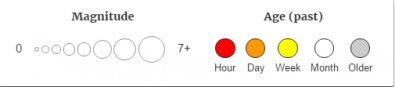
After first going to the website, they need to look at the map and decide which two continents appear to have the most recent earthquakes. They will then use the time key and see if they can spot any earthquakes in the world that have happened in the past hour. One of the reasons I like this assignment, is that it is possible to have multiple classes with different answers based on current earthquakes.
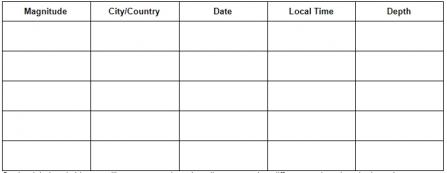
Students will then find the 5 largest earthquakes that have happened in the last 30 days around the world. They will fill out a table of the magnitude, city or country, date, local time, and depth of the earthquake focus. When it comes time to putting the local time, I have students convert the UTC time into their local time. In Arizona that would be the UTC minus 7 hours. Depending on where you live will depend on the type of answer you might get from students. Converting the UTC time is a review of an activity that we did earlier.
After filling out the table students will click on the DYFI (Did You Feel It) option. This demonstrates to students that you can text or email in to the USGS when feeling an earthquake. The USGS then can look at your time stamp of when you felt it and then correlate that with other messages from other people. https://earthquake.usgs.gov/data/dyfi/ This question also demonstrates to students that in some areas in states like California, many many people will respond to the quaking.
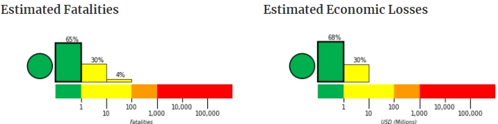
In the next part of the assignment, students will look at the Mercalli scale, and describe what it would have felt like or what possible damage might have occurred for one of the large earthquakes they have been looking at. Students will then click on the "Pager" button and analyze some graphs and ranges of possible fatalities and economic losses.
The last set of questions deals with analyzing a shake map and a table of data based on a shake map. On the shake map students will see that strength of an earthquake diminishes over distance. Students will also be able to see how many people would have felt the different intensities based on the Mercalli Intensity Scale.

This assignment takes about a full class hour of about 55 minutes. Students who read well and concentrate can finish it earlier. I let students work in groups of 1, 2, or 3, sharing a single computer and discussing the questions.